
Corcoran topographic map
Click on the map to display elevation.
Corcoran
Corcoran is a city in Kings County, California, United States. The population was 24,813 (2010 census), up from 14,458 (2000 census). Corcoran is located 17 miles (27 km) south-southeast of Hanford, at an elevation of 207 ft (63 m).
About this map
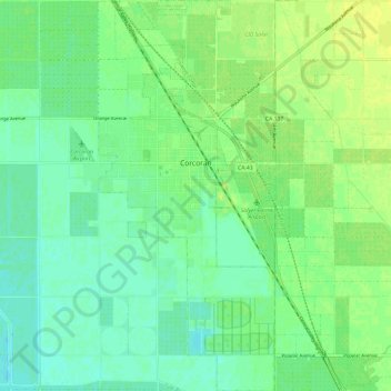
Name: Corcoran topographic map, elevation, terrain.
Location: Corcoran, Kings County, California, 93212, United States (36.04202 -119.58996 36.13794 -119.53634)
Average elevation: 62 m
Minimum elevation: 54 m
Maximum elevation: 69 m
Other topographic maps
Click on a map to view its topography, its elevation and its terrain.
Armona
United States > California > Kings County
Armona is a census-designated place (CDP) in Kings County, California, United States. Armona is located 3.5 miles (5.6 km) west-southwest of Hanford, at an elevation of 239 feet (73 m). It is part of the Hanford–Corcoran Metropolitan Statistical Area. The population was 4,156 at the 2010 census. Armona's…
Average elevation: 70 m