
Make a donation
Gear up for your next adventure:
As an Amazon Associate, this site earns from qualifying purchases at no extra cost to you.
Front Royal topographic map
Click on the map to display elevation.
Make a donation
Gear up for your next adventure:
As an Amazon Associate, this site earns from qualifying purchases at no extra cost to you.
Front Royal
Front Royal, located in Warren County, Virginia, sits at an elevation of approximately 570 feet (174 meters) above sea level. It lies in a diverse topographic region, with the town nestled at the confluence of the North and South Forks of the Shenandoah River, which contributes to its distinctive river valley landscape. The surrounding terrain is marked by rolling hills and moderate elevation changes, with some areas rising into the foothills of the Blue Ridge Mountains to the east. The area's proximity to these mountains results in a natural divide, with the town situated in a relatively low-lying area within the larger Shenandoah Valley.
Make a donation
Gear up for your next adventure:
As an Amazon Associate, this site earns from qualifying purchases at no extra cost to you.
About this map
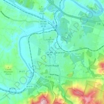
Name: Front Royal topographic map, elevation, terrain.
Location: Front Royal, Warren County, Virginia, United States (38.89164 -78.22068 38.96222 -78.14276)
Average elevation: 194 m
Minimum elevation: 132 m
Maximum elevation: 408 m
Make a donation
Gear up for your next adventure:
As an Amazon Associate, this site earns from qualifying purchases at no extra cost to you.
Other topographic maps
Click on a map to view its topography, its elevation and its terrain.