
Make a donation
Gear up for your next adventure:
As an Amazon Associate, this site earns from qualifying purchases at no extra cost to you.
Merrimac topographic map
Click on the map to display elevation.
Make a donation
Gear up for your next adventure:
As an Amazon Associate, this site earns from qualifying purchases at no extra cost to you.
About this map
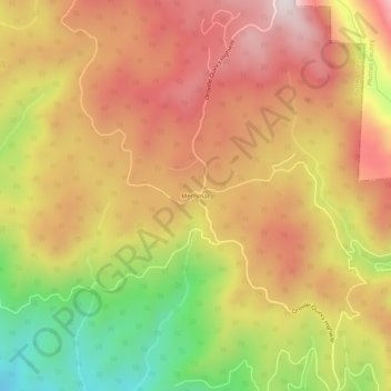
Name: Merrimac topographic map, elevation, terrain.
Average elevation: 1,191 m
Minimum elevation: 793 m
Maximum elevation: 1,485 m
Make a donation
Gear up for your next adventure:
As an Amazon Associate, this site earns from qualifying purchases at no extra cost to you.
Other topographic maps
Click on a map to view its topography, its elevation and its terrain.
Chico
United States > California > Butte County
An altitude record for unmanned gas balloons was set in Chico in October 1972 (51.8 km or 32.2 mi). The record was broken on May 23, 2002.
Average elevation: 95 m
Paradise
United States > California > Butte County
Paradise lies within the foothills of the Sierra Nevada mountain range, at an elevation that varies between 900 and 2,300 feet (275 to 700 meters) above sea level. The town is perched on a broad ridge, with steep canyons on either side—these are carved by the Feather River to the east and Butte Creek to the…
Average elevation: 464 m
Chico
United States > California > Butte County
An altitude record for unmanned gas balloons was set in Chico in October 1972 (51.8 km or 32.2 mi). The record was broken on May 23, 2002.
Average elevation: 95 m
Make a donation
Gear up for your next adventure:
As an Amazon Associate, this site earns from qualifying purchases at no extra cost to you.
Paradise
United States > California > Butte County
The town is spread out on a wide ridge between deep canyons formed by the west branch of the Feather River to the east and Butte Creek to the west. The Paradise area extends northward to include the unincorporated town of Magalia, as well as Stirling City, eleven miles (18 km) north. Elevation of the area…
Average elevation: 464 m
Make a donation
Gear up for your next adventure:
As an Amazon Associate, this site earns from qualifying purchases at no extra cost to you.
Make a donation
Gear up for your next adventure:
As an Amazon Associate, this site earns from qualifying purchases at no extra cost to you.
Paradise
United States > California > Butte County
The town is spread out on a wide ridge between deep canyons formed by the west branch of the Feather River to the east and Butte Creek to the west. The Paradise area extends northward to include the unincorporated town of Magalia, as well as Stirling City, eleven miles (18 km) north. Elevation of the area…
Average elevation: 464 m