Geolocate

Tumpagon topographic map

Click on the map to display elevation.

About this map
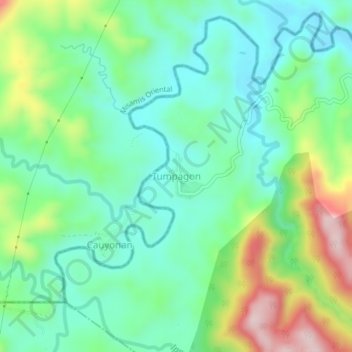
Name: Tumpagon topographic map, elevation, terrain.

Location: Tumpagon, Cagayan de Oro, Northern Mindanao, 9000, Philippines (8.31059 124.44114 8.35059 124.48114)

Average elevation: 213 m

Minimum elevation: 110 m

Maximum elevation: 448 m

Other topographic maps

Click on a map to view its topography, its elevation and its terrain.

Calaanan Creek

Philippines > Cagayan de Oro

Average elevation: 70 m

Divisoria Plaza

Philippines > Cagayan de Oro

Average elevation: 11 m

Gaston Park

Philippines > Cagayan de Oro

Average elevation: 13 m

Rodelsa Circle

Philippines > Cagayan de Oro

Average elevation: 19 m

Iponan River

Philippines > Cagayan de Oro

Average elevation: 73 m

Xavier Heights

Philippines > Cagayan de Oro

Average elevation: 96 m

Agusan River

Philippines > Cagayan de Oro

Average elevation: 197 m

Divisoria Plaza

Philippines > Cagayan de Oro

Average elevation: 11 m

Divisoria Plaza

Philippines > Cagayan de Oro

Average elevation: 11 m

Rodelsa Circle

Philippines > Cagayan de Oro

Average elevation: 19 m

Gear up for your next adventure:

🌬️Windbreaker Jackets - Wind protection jackets
🔪Outdoor Multi-tools - Versatile tools for gear repair and survival tasks in the wilderness
📍Handheld GPS - GPS devices for hiking and navigation
🍴Titanium Spork & Cutlery - Indestructible and feather-light eating utensils
🦟Heavy Duty Insect Repellent - Essential protection against flies, mozzies, and march flies

As an Amazon Associate, this site earns from qualifying purchases at no extra cost to you.