Geolocate

Bøstad topographic map

Click on the map to display elevation.

About this map

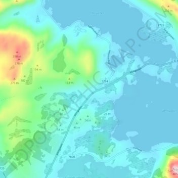
Name: Bøstad topographic map, elevation, terrain.

Location: Bøstad, Vestvågøy, Nordland, 8360, Norway (68.23211 13.74656 68.27211 13.78656)

Average elevation: 56 m

Minimum elevation: 0 m

Maximum elevation: 393 m

Other topographic maps

Click on a map to view its topography, its elevation and its terrain.

Grane

Norway > Nordland

Average elevation: 582 m

Beiarn

Norway > Nordland

Average elevation: 639 m

Lødingen

Norway > Nordland

Average elevation: 140 m

Andøy

Norway > Nordland

Average elevation: 31 m

Gildeskål

Norway > Nordland

Average elevation: 225 m

Narvik

Norway > Nordland

Average elevation: 509 m

Vågan

Norway > Nordland

Average elevation: 62 m

Gear up for your next adventure:

📟Satellite Messengers - Two-way satellite communication to stay in touch beyond the cellular grid
🩹First Aid Kits - Emergency kits for hiking
🔪Outdoor Multi-tools - Versatile tools for gear repair and survival tasks in the wilderness
🪢Paracord - Multi-purpose survival cord
🧥Down Jackets - Insulated jackets for cold weather

As an Amazon Associate, this site earns from qualifying purchases at no extra cost to you.