
Make a donation
Gear up for your next adventure:
As an Amazon Associate, this site earns from qualifying purchases at no extra cost to you.
Bissingen topographic map
Click on the map to display elevation.
Make a donation
Gear up for your next adventure:
As an Amazon Associate, this site earns from qualifying purchases at no extra cost to you.
About this map
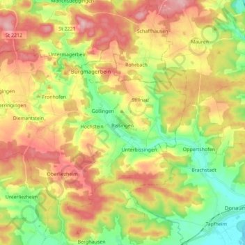
Name: Bissingen topographic map, elevation, terrain.
Average elevation: 486 m
Minimum elevation: 400 m
Maximum elevation: 580 m
Make a donation
Gear up for your next adventure:
As an Amazon Associate, this site earns from qualifying purchases at no extra cost to you.
Other topographic maps
Click on a map to view its topography, its elevation and its terrain.
Kicklingen
Deutschland > Bayern > Landkreis Dillingen an der Donau > Dillingen a.d.Donau
Average elevation: 418 m
Make a donation
Gear up for your next adventure:
As an Amazon Associate, this site earns from qualifying purchases at no extra cost to you.
Veitriedhausen
Deutschland > Bayern > Landkreis Dillingen an der Donau > Lauingen (Donau)
Average elevation: 446 m
Make a donation
Gear up for your next adventure:
As an Amazon Associate, this site earns from qualifying purchases at no extra cost to you.
Leitenhof
Deutschland > Bayern > Landkreis Dillingen an der Donau > Bissingen
Average elevation: 499 m
Baumgarten
Deutschland > Bayern > Landkreis Dillingen an der Donau
Baumgarten ist ein Ortsteil der Gemeinde Aislingen im schwäbischen Landkreis Dillingen an der Donau. Baumgarten, das zum 1. Mai 1978 zusammen mit dem damaligen Ortsteil Windhausen in die Gemeinde Aislingen eingegliedert wurde, liegt drei Kilometer südwestlich von Aislingen im Tal des Aislinger Baches. Die…
Average elevation: 490 m
Make a donation
Gear up for your next adventure:
As an Amazon Associate, this site earns from qualifying purchases at no extra cost to you.
Illemad
Deutschland > Bayern > Landkreis Dillingen an der Donau > Buttenwiesen
Average elevation: 437 m
Make a donation
Gear up for your next adventure:
As an Amazon Associate, this site earns from qualifying purchases at no extra cost to you.
Faimingen
Deutschland > Bayern > Landkreis Dillingen an der Donau > Lauingen (Donau)
Average elevation: 434 m
Fristingen
Deutschland > Bayern > Landkreis Dillingen an der Donau > Dillingen a.d.Donau > Fristingen
Average elevation: 420 m
Make a donation
Gear up for your next adventure:
As an Amazon Associate, this site earns from qualifying purchases at no extra cost to you.