
Ghaziabad topographic map
Interactive map
Click on the map to display elevation.
Ghaziabad
The district center is the village of Ghaziabad (34°42′57″N 70°45′33″E / 34.7158°N 70.7592°E / 34.7158; 70.7592) at 1,271 metres (4,170 ft) altitude. The area is mountainous and there is little arable land. Many of its residents work in Pakistan.
About this map
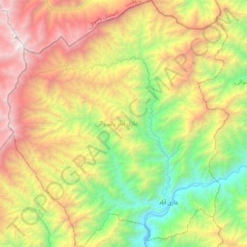
Name: Ghaziabad topographic map, elevation, terrain.
Location: Ghaziabad, Kunar Province, Afghanistan (35.09682 71.17537 35.36696 71.47193)
Average elevation: 2,472 m
Minimum elevation: 935 m
Maximum elevation: 4,723 m