
Mount Cook topographic map
Click on the map to display elevation.
Mount Cook
Aoraki / Mount Cook is the highest mountain in New Zealand. Its height, as of 2014, is listed as 3,724 metres (12,218 feet). It is situated in the Southern Alps, the mountain range that runs the length of the South Island. A popular tourist destination, it is also a favourite challenge for mountaineers. Aoraki / Mount Cook consists of three summits: from south to north, the Low Peak (3,593 m or 11,788 ft), the Middle Peak (3,717 m or 12,195 ft) and the High Peak. The summits lie slightly south and east of the main divide of the Southern Alps, with the Tasman Glacier to the east and the Hooker Glacier to the southwest. Mount Cook is ranked 10th in the world by topographic isolation.
About this map
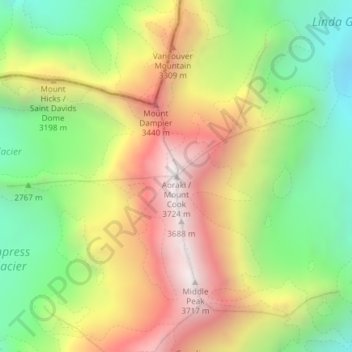
Name: Mount Cook topographic map, elevation, terrain.
Location: Mount Cook, Mackenzie District, Canterbury, New Zealand (-43.59505 170.14212 -43.59495 170.14222)
Average elevation: 2,920 m
Minimum elevation: 2,235 m
Maximum elevation: 3,709 m
Other topographic maps
Click on a map to view its topography, its elevation and its terrain.
Tasman Glacier
New Zealand > Canterbury > Mackenzie District
At 23.5 kilometres (14.6 mi) in length, Tasman Glacier is still New Zealand's longest glacier, despite shrinking considerably from the 1990s onwards. It is as much as 4 kilometres (2.5 mi) wide and 600 metres (2,000 ft) thick, and lies entirely within the borders of Aoraki / Mount Cook National Park. The…
Average elevation: 1,884 m
Aoraki / Mount Cook National Park
New Zealand > Canterbury > Mackenzie District
Temperatures in Mount Cook Village range between extremes of −13 °C (9 °F) to 32 °C (90 °F), and typically fall just over 1 °C (34 °F) for every 200 metres (660 ft) of additional altitude.
Average elevation: 1,386 m
Lake Tekapo
New Zealand > Canterbury > Mackenzie District
Lake Tekapo (Māori: Takapō) is the second-largest of three roughly parallel lakes running north–south along the northern edge of the Mackenzie Basin in the South Island of New Zealand (the others are Lake Pukaki and Lake Ōhau). It covers an area of 83 square kilometres (32 sq mi) and is at an altitude of…
Average elevation: 1,025 m
Aoraki / Mount Cook National Park
New Zealand > Canterbury > Mackenzie District
Temperatures in Mount Cook Village range between extremes of −13 °C (9 °F) to 32 °C (90 °F), and typically fall just over 1 °C (34 °F) for every 200 metres (660 ft) of additional altitude.
Average elevation: 1,386 m
Tasman Glacier
New Zealand > Canterbury > Mackenzie District
At 23.5 kilometres (14.6 mi) in length, Tasman Glacier is still New Zealand's longest glacier, despite shrinking considerably from the 1990s onwards. It is as much as 4 kilometres (2.5 mi) wide and 600 metres (2,000 ft) thick, and lies entirely within the borders of Aoraki / Mount Cook National Park. The…
Average elevation: 1,884 m