
Thank you for supporting this site ❤️
Make a donation
Make a donation
Gear up for your next adventure:
As an Amazon Associate, this site earns from qualifying purchases at no extra cost to you.
Carapito topographic map
Click on the map to display elevation.
Thank you for supporting this site ❤️
Make a donation
Make a donation
Gear up for your next adventure:
As an Amazon Associate, this site earns from qualifying purchases at no extra cost to you.
About this map
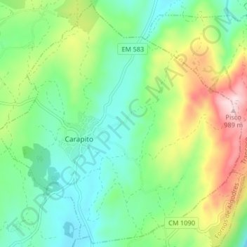
Name: Carapito topographic map, elevation, terrain.
Location: Carapito, Aguiar da Beira, Guarda, 3570-100, Portugal (40.74366 -7.48696 40.79151 -7.42198)
Average elevation: 729 m
Minimum elevation: 634 m
Maximum elevation: 914 m
Thank you for supporting this site ❤️
Make a donation
Make a donation
Gear up for your next adventure:
As an Amazon Associate, this site earns from qualifying purchases at no extra cost to you.