
Rathmell topographic map
Interactive map
Click on the map to display elevation.
About this map
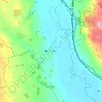
Name: Rathmell topographic map, elevation, terrain.
Location: Rathmell, North Yorkshire, England, BD24 0FG, United Kingdom (54.01519 -2.32040 54.05519 -2.28040)
Average elevation: 172 m
Minimum elevation: 121 m
Maximum elevation: 315 m
Other topographic maps
Click on a map to view its topography, its elevation and its terrain.
Osgodby
United Kingdom > England > North Yorkshire
Osgodby, North Yorkshire, England, YO11 3PT, United Kingdom
Average elevation: 43 m
Scarborough
United Kingdom > England > North Yorkshire
Scarborough, North Yorkshire, England, YO11 1LP, United Kingdom
Average elevation: 39 m
Esk Valley
United Kingdom > England > North Yorkshire > Scarborough > Grosmont
Esk Valley, Grosmont, Scarborough, North Yorkshire, England, YO22 5BG, United Kingdom
Average elevation: 127 m
Whitby
United Kingdom > England > North Yorkshire
Whitby, Scarborough, North Yorkshire, England, United Kingdom
Average elevation: 37 m
Selby
United Kingdom > England > North Yorkshire > Selby
Selby, North Yorkshire, England, United Kingdom
Average elevation: 7 m