
Make a donation
Gear up for your next adventure:
As an Amazon Associate, this site earns from qualifying purchases at no extra cost to you.
Cimarron topographic map
Click on the map to display elevation.
Make a donation
Gear up for your next adventure:
As an Amazon Associate, this site earns from qualifying purchases at no extra cost to you.
About this map
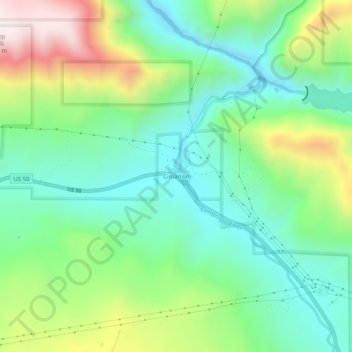
Name: Cimarron topographic map, elevation, terrain.
Location: Cimarron, Montrose County, Colorado, 81220, United States (38.42249 -107.57673 38.46249 -107.53673)
Average elevation: 2,334 m
Minimum elevation: 2,063 m
Maximum elevation: 2,898 m
Make a donation
Gear up for your next adventure:
As an Amazon Associate, this site earns from qualifying purchases at no extra cost to you.
Other topographic maps
Click on a map to view its topography, its elevation and its terrain.
Black Canyon of the Gunnison National Park
United States > Colorado > Montrose County
Average elevation: 2,225 m
Make a donation
Gear up for your next adventure:
As an Amazon Associate, this site earns from qualifying purchases at no extra cost to you.
Black Canyon of the Gunnison Wilderness
United States > Colorado > Montrose County
Average elevation: 2,163 m