
Thank you for supporting this site ❤️
Make a donation
Make a donation
Gear up for your next adventure:
As an Amazon Associate, this site earns from qualifying purchases at no extra cost to you.
Baranquilla topographic map
Click on the map to display elevation.
Thank you for supporting this site ❤️
Make a donation
Make a donation
Gear up for your next adventure:
As an Amazon Associate, this site earns from qualifying purchases at no extra cost to you.
About this map
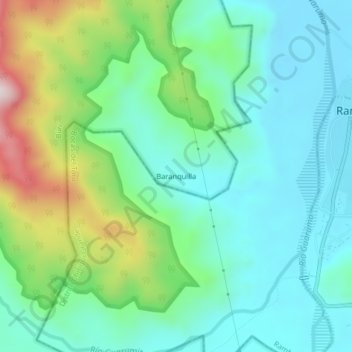
Name: Baranquilla topographic map, elevation, terrain.
Location: Baranquilla, Bürí, Distrito Jirondai, Ngäbe-Buglé, Panamá (8.90102 -82.22356 8.94102 -82.18356)
Average elevation: 152 m
Minimum elevation: 6 m
Maximum elevation: 559 m
Thank you for supporting this site ❤️
Make a donation
Make a donation
Gear up for your next adventure:
As an Amazon Associate, this site earns from qualifying purchases at no extra cost to you.