
Wiveliscombe topographic map
Interactive map
Click on the map to display elevation.
About this map
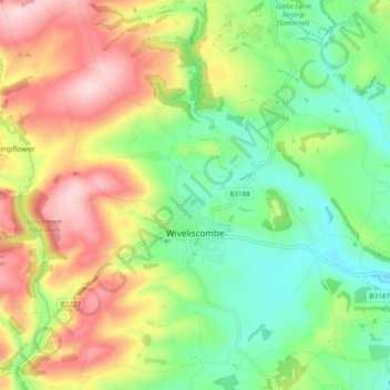
Name: Wiveliscombe topographic map, elevation, terrain.
Location: Wiveliscombe, Somerset, England, United Kingdom (51.02317 -3.36020 51.07285 -3.26359)
Average elevation: 166 m
Minimum elevation: 62 m
Maximum elevation: 311 m
Wiveliscombe is a former borough, market and cloth making town, 5 miles (8 km) from the border between Devon and Somerset. It is situated at the foot of the Brendon Hills and acts as a gateway to Exmoor. At an altitude of 126 m (413 ft) Wiveliscombe is the highest town in Somerset after Dulverton.
Other topographic maps
Click on a map to view its topography, its elevation and its terrain.
Leigh upon Mendip
United Kingdom > England > Somerset
Leigh upon Mendip, Somerset, England, BA3 5QQ, United Kingdom
Average elevation: 177 m
Mells
United Kingdom > England > Somerset
Mells, Somerset, England, United Kingdom
Average elevation: 133 m
Bridgwater
United Kingdom > England > Somerset
Bridgwater, Somerset, England, United Kingdom
Average elevation: 10 m
Pawlett
United Kingdom > England > Somerset
Pawlett, Somerset, England, United Kingdom
Average elevation: 6 m