Geolocate

Gunpoint topographic map

Click on the map to display elevation.

About this map

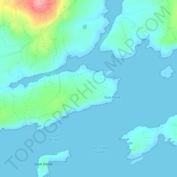
Name: Gunpoint topographic map, elevation, terrain.

Location: Gunpoint, Lowertown, West Cork, County Cork, Munster, Ireland (51.49498 -9.59944 51.50260 -9.58401)

Average elevation: 14 m

Minimum elevation: -3 m

Maximum elevation: 108 m

Other topographic maps

Click on a map to view its topography, its elevation and its terrain.

Waterfall

Ireland > County Cork

Average elevation: 96 m

The Glen

Ireland > County Cork > Cork

Average elevation: 57 m

Kinsale

Ireland > County Cork > Kinsale

Average elevation: 44 m

Glenbrook

Ireland > County Cork

Average elevation: 50 m

Gear up for your next adventure:

🎽Base Layers - Thermal base layers
🚴Bike GPS - GPS devices for cycling
👣Snake & Scrub Gaiters - Protection against spinifex, mud, and snakes while walking off-track
🧣Merino Neck Gaiters - Versatile headwear for warmth, sun protection, or dust filtering
🎒40L Day Hiking Backpacks - Comfortable packs with hydration support for long days exploring topographic peaks

As an Amazon Associate, this site earns from qualifying purchases at no extra cost to you.