
Esshoff topographic map
Interactive map
Click on the map to display elevation.
About this map
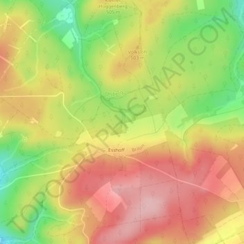
Name: Esshoff topographic map, elevation, terrain.
Average elevation: 489 m
Minimum elevation: 391 m
Maximum elevation: 564 m
Other topographic maps
Click on a map to view its topography, its elevation and its terrain.
Hoppecke
Deutschland > Nordrhein-Westfalen > Brilon
Hoppecke, Brilon, Hochsauerlandkreis, Regierungsbezirk Arnsberg, Nordrhein-Westfalen, Deutschland
Average elevation: 572 m
Allenberg
Deutschland > Nordrhein-Westfalen > Brilon
Allenberg, Brilon, Hochsauerlandkreis, Regierungsbezirk Arnsberg, Nordrhein-Westfalen, Deutschland
Average elevation: 408 m
Aabach
Deutschland > Nordrhein-Westfalen > Brilon
Aabach, Brilon, Hochsauerlandkreis, Regierungsbezirk Arnsberg, Nordrhein-Westfalen, Deutschland
Average elevation: 459 m