
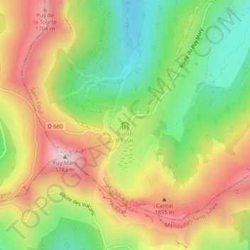
Refuge du buron d'Eylac topographic map
Interactive map
Click on the map to display elevation.
About this map
Name: Refuge du buron d'Eylac topographic map, elevation, terrain.
Average elevation: 1,427 m
Minimum elevation: 1,126 m
Maximum elevation: 1,762 m
Other topographic maps
Click on a map to view its topography, its elevation and its terrain.
Puy de Niermont
France > Auvergne-Rhône-Alpes > Cantal > Le Claux
Puy de Niermont, Le Claux, Saint-Flour, Cantal, Auvergne-Rhône-Alpes, France métropolitaine, 15400, France
Average elevation: 1,363 m
Enchaniers
France > Auvergne-Rhône-Alpes > Cantal > Le Claux
Enchaniers, Le Claux, Saint-Flour, Cantal, Auvergne-Rhône-Alpes, France métropolitaine, 15400, France
Average elevation: 1,188 m
La Maurinie
France > Auvergne-Rhône-Alpes > Cantal > Le Claux
La Maurinie, Le Claux, Saint-Flour, Cantal, Auvergne-Rhône-Alpes, France métropolitaine, 15400, France
Average elevation: 1,279 m