
Andacollo topographic map
Interactive map
Click on the map to display elevation.
About this map
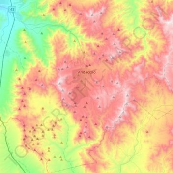
Name: Andacollo topographic map, elevation, terrain.
Location: Andacollo, Provincia de Elqui, Región de Coquimbo, Chile (-30.40419 -71.22128 -30.10962 -70.90594)
Average elevation: 840 m
Minimum elevation: 112 m
Maximum elevation: 1,562 m
Andacollo ist ein Wallfahrtsort im südamerikanischen Anden-Staat Chile, ca. 50 km südöstlich von La Serena / Coquimbo auf einer Höhe von 1053 m über dem Meeresspiegel gelegen. Er gehört zur Región de Coquimbo (Region IV), Provinz Elqui. Die Einwohnerzahl beträgt 10.288 (Stand 2002). Das Wort Andacollo kommt aus dem Quechua „anta-colla“, welches „Königin des Kupfers“ bedeutet.