
Cayambe topographic map
Interactive map
Click on the map to display elevation.
About this map
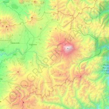
Name: Cayambe topographic map, elevation, terrain.
Location: Cayambe, Pichincha, Ecuador (-0.19557 -78.32181 0.18838 -77.83973)
Average elevation: 3,394 m
Minimum elevation: 1,975 m
Maximum elevation: 5,767 m
Other topographic maps
Click on a map to view its topography, its elevation and its terrain.
Pucará Grande
Ecuador > Pichincha > Cayambe > Cangahua
Pucará Grande, Cangahua, Cayambe, Pichincha, 171416, Ecuador
Average elevation: 3,541 m