
Wynarka topographic map
Interactive map
Click on the map to display elevation.
About this map
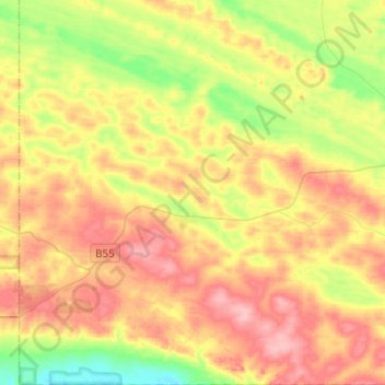
Name: Wynarka topographic map, elevation, terrain.
Average elevation: 78 m
Minimum elevation: 20 m
Maximum elevation: 135 m
Other topographic maps
Click on a map to view its topography, its elevation and its terrain.
Karoonda
Australia > South Australia > The District Council of Karoonda East Murray
Karoonda, The District Council of Karoonda East Murray, South Australia, 5307, Australia
Average elevation: 72 m
Wanbi
Australia > South Australia > The District Council of Karoonda East Murray > Wanbi
Wanbi, The District Council of Karoonda East Murray, South Australia, 5310, Australia
Average elevation: 74 m