
Centre ville - Urbanistes topographic map
Interactive map
Click on the map to display elevation.
About this map
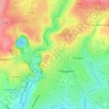
Name: Centre ville - Urbanistes topographic map, elevation, terrain.
Average elevation: 116 m
Minimum elevation: 69 m
Maximum elevation: 169 m
Other topographic maps
Click on a map to view its topography, its elevation and its terrain.
Forairie - Cotterêts
Forairie - Cotterêts, Fougères, Fougères-Vitré, Ille-et-Vilaine, Bretagne, France métropolitaine, 35300, France
Average elevation: 136 m
Écartelée - Bonabry - Orières - Paron
Écartelée - Bonabry - Orières - Paron, Fougères, Fougères-Vitré, Ille-et-Vilaine, Bretagne, France métropolitaine, 35300, France
Average elevation: 106 m