Geolocate

Autazes topographic map

Click on the map to display elevation.

About this map
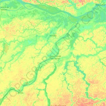
Name: Autazes topographic map, elevation, terrain.

Location: Autazes, Região Geográfica Imediata de Manaus, Região Geográfica Intermediária de Manaus, Amazonas, North Region, Brazil (-4.42000 -60.28600 -3.24300 -58.78700)

Average elevation: 28 m

Minimum elevation: 4 m

Maximum elevation: 96 m

Other topographic maps

Click on a map to view its topography, its elevation and its terrain.

Juami River

Brazil > Amazonas > Japurá

Juami River is a black water river, a tributary of the white water Japurá River, and runs through the Amazon plain. The entire basin of the Juami River is contained within the Juami-Japurá Ecological Station. The basin has altitudes that range from 45 to 450 metres (148 to 1,476 ft) above sea level.

Average elevation: 109 m

Gear up for your next adventure:

👖Convertible Hiking Trousers - Zip-off legs to adapt to changing temperatures throughout the day
🧼Clip-on Hand Sanitizer - Maintain hygiene when water for washing is scarce
🔥Camping Stoves - Portable stoves for outdoor cooking
🏃Compression Recovery Socks - Reduce leg fatigue after heavy days of elevation gain
🔭Compact Hiking Binoculars - Lightweight optics for scouting routes or birdwatching

As an Amazon Associate, this site earns from qualifying purchases at no extra cost to you.