
Villa Pehuenia topographic map
Interactive map
Click on the map to display elevation.
About this map
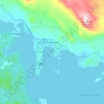
Name: Villa Pehuenia topographic map, elevation, terrain.
Average elevation: 1,240 m
Minimum elevation: 1,145 m
Maximum elevation: 1,759 m
Villa Pehuenia sprawls over about 5 kilometres (3.1 mi) of the northern shore of Lake Aluminé, but is concentrated on two narrow peninsulas extending out into the lake. Rising near the village is the Batea Mahuida volcano which reaches a maximum elevation of 1,948 metres (6,391 ft) about 8 kilometres (5.0 mi) north of the Villa Pehuenia. A small ski resort is operated on the slopes of the volcano by the Puel people.
Other topographic maps
Click on a map to view its topography, its elevation and its terrain.
Villa La Angostura
Argentina > Neuquén Province > Villa La Angostura
Villa La Angostura, Departamento Los Lagos, Neuquén Province, Argentina
Average elevation: 928 m