
Santurce topographic map
Interactive map
Click on the map to display elevation.
About this map
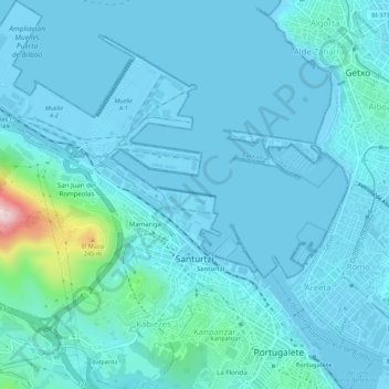
Name: Santurce topographic map, elevation, terrain.
Location: Santurce, Andraka, Vizcaya, País Vasco, 48620, España (43.31529 -3.07114 43.35536 -3.02287)
Average elevation: 34 m
Minimum elevation: -3 m
Maximum elevation: 360 m
Other topographic maps
Click on a map to view its topography, its elevation and its terrain.
Ría de Bilbao
España > País Vasco > Andraka > Erandio
Ría de Bilbao, Basurtu-Zorrotza, Erandio, Andraka, Vizcaya, País Vasco, 48620, España
Average elevation: 28 m
Gorostiaga
España > País Vasco > Andraka > Baquio
Gorostiaga, Baquio, Andraka, Vizcaya, País Vasco, 48620, España
Average elevation: 85 m