
Le Lavoir topographic map
Interactive map
Click on the map to display elevation.
About this map
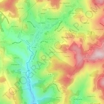
Name: Le Lavoir topographic map, elevation, terrain.
Average elevation: 596 m
Minimum elevation: 432 m
Maximum elevation: 776 m
Other topographic maps
Click on a map to view its topography, its elevation and its terrain.
La Villette
France > Auvergne-Rhône-Alpes > Rhône > Cours > Cours-la-Ville > La Villette
La Villette, Cours-la-Ville, Cours, Villefranche-sur-Saône, Rhône, Circonscription départementale du Rhône, Auvergne-Rhône-Alpes, France métropolitaine, 69470, France
Average elevation: 607 m