
Castella topographic map
Interactive map
Click on the map to display elevation.
About this map
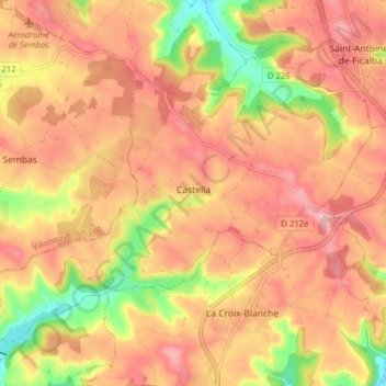
Name: Castella topographic map, elevation, terrain.
Average elevation: 190 m
Minimum elevation: 105 m
Maximum elevation: 238 m
Other topographic maps
Click on a map to view its topography, its elevation and its terrain.
Agen
France > Nouvelle-Aquitaine > Lot-et-Garonne
Agen, Lot-et-Garonne, Nouvelle-Aquitaine, Metropolitan France, 47000, France
Average elevation: 65 m
Trémons
France > Nouvelle-Aquitaine > Lot-et-Garonne
Trémons, Villeneuve-sur-Lot, Lot-et-Garonne, Nouvelle-Aquitaine, Metropolitan France, 47140, France
Average elevation: 114 m
Brugnac
France > Nouvelle-Aquitaine > Lot-et-Garonne
Brugnac, Marmande, Lot-et-Garonne, Nouvelle-Aquitaine, Metropolitan France, 47260, France
Average elevation: 77 m