
Kalamazoo topographic map
Interactive map
Click on the map to display elevation.
About this map
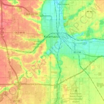
Name: Kalamazoo topographic map, elevation, terrain.
Location: Kalamazoo, Kalamazoo County, Michigan, United States (42.21556 -85.66271 42.33275 -85.53078)
Average elevation: 265 m
Minimum elevation: 227 m
Maximum elevation: 307 m
Other topographic maps
Click on a map to view its topography, its elevation and its terrain.
South Gull Lake
United States > Michigan > Kalamazoo County
South Gull Lake, Ross Township, Kalamazoo County, Michigan, 49060, United States
Average elevation: 274 m
Comstock Charter Township
United States > Michigan > Kalamazoo County
Comstock Charter Township, Kalamazoo County, Michigan, United States
Average elevation: 259 m
Kalamazoo Charter Township
United States > Michigan > Kalamazoo County
Kalamazoo Charter Township, Kalamazoo County, Michigan, 49006, United States
Average elevation: 272 m
Cooper Charter Township
United States > Michigan > Kalamazoo County
Cooper Charter Township, Kalamazoo County, Michigan, United States
Average elevation: 261 m
Oakwood
United States > Michigan > Kalamazoo County > Kalamazoo
Oakwood, Kalamazoo, Kalamazoo County, Michigan, 49008, United States
Average elevation: 274 m
Parchment
United States > Michigan > Kalamazoo County
Parchment, Kalamazoo County, Michigan, 49004, United States
Average elevation: 244 m
Comstock
United States > Michigan > Kalamazoo County
Comstock, Charter Township of Comstock, Kalamazoo County, Michigan, 49048, United States
Average elevation: 248 m
Oshtemo Township
United States > Michigan > Kalamazoo County
Oshtemo Township, Kalamazoo County, Michigan, 49009, United States
Average elevation: 283 m
Alamo Township
United States > Michigan > Kalamazoo County
Alamo Township, Kalamazoo County, Michigan, United States
Average elevation: 245 m
Milwood
United States > Michigan > Kalamazoo County > Kalamazoo > Milwood
Milwood, Kalamazoo, Kalamazoo County, Michigan, 49001, United States
Average elevation: 255 m
Richland
United States > Michigan > Kalamazoo County > Richland
Richland, Richland Township, Kalamazoo County, Michigan, 49083, United States
Average elevation: 282 m
Hogset Lake
United States > Michigan > Kalamazoo County
Hogset Lake, Schoolcraft Township, Kalamazoo County, Michigan, United States
Average elevation: 263 m
Westwood
United States > Michigan > Kalamazoo County > Westwood
Westwood, Kalamazoo Charter Township, Kalamazoo County, Michigan, 49006, United States
Average elevation: 279 m
Portage
United States > Michigan > Kalamazoo County
Portage, Kalamazoo County, Michigan, United States
Average elevation: 266 m