
North Andros topographic map
Interactive map
Click on the map to display elevation.
About this map
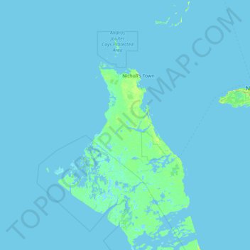
Name: North Andros topographic map, elevation, terrain.
Location: North Andros, The Bahamas (24.26900 -78.74703 25.50600 -77.33451)
Average elevation: 1 m
Minimum elevation: -4 m
Maximum elevation: 38 m
Other topographic maps
Click on a map to view its topography, its elevation and its terrain.
Water Cay
The Bahamas > East Grand Bahama
Water Cay, East Grand Bahama, The Bahamas
Average elevation: 0 m
Emerald Ridge
Emerald Ridge, New Providence, The Bahamas
Average elevation: 7 m
Anderson Settlement
The Bahamas > Anderson Settlement
Anderson Settlement, The Bahamas
Average elevation: 3 m
Grand Bahama
The Bahamas > East Grand Bahama
Grand Bahama, East Grand Bahama, The Bahamas
Average elevation: 1 m
Village Green
The Bahamas > Village Green > New Providence
Village Green, New Providence, The Bahamas
Average elevation: 7 m