
Sudbury topographic map
Interactive map
Click on the map to display elevation.
About this map
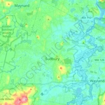
Name: Sudbury topographic map, elevation, terrain.
Average elevation: 57 m
Minimum elevation: 28 m
Maximum elevation: 178 m
Other topographic maps
Click on a map to view its topography, its elevation and its terrain.
Picking Conservation Land East
United States > Massachusetts > Middlesex County > Westford
Average elevation: 73 m
Bowman Park
United States > Massachusetts > Middlesex County > Lexington > East Lexington
Average elevation: 70 m
Lowell
United States > Massachusetts > Middlesex County > Lowell
Lowell is located at the confluence of the Merrimack and Concord rivers. The Pawtucket Falls, a mile-long set of rapids with a total drop in elevation of 32 feet, ends where the two rivers meet. At the top of the falls is the Pawtucket Dam, designed to turn the upper Merrimack into a millpond, diverted through…
Average elevation: 55 m