
Thron topographic map
Interactive map
Click on the map to display elevation.
About this map
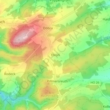
Name: Thron topographic map, elevation, terrain.
Average elevation: 657 m
Minimum elevation: 548 m
Maximum elevation: 794 m
Other topographic maps
Click on a map to view its topography, its elevation and its terrain.
Straßdorf
Deutschland > Bayern > Landkreis Hof > Schwarzenbach a.Wald
Straßdorf, Schwarzenbach a.Wald, Landkreis Hof, Bayern, 95131, Deutschland
Average elevation: 646 m
Rauschenhammermühle
Deutschland > Bayern > Landkreis Hof > Schwarzenbach a.Wald > Schwarzenstein > Rauschenhammermühle
Rauschenhammermühle, Schwarzenstein, Schwarzenbach a.Wald, Landkreis Hof, Bayern, 95131, Deutschland
Average elevation: 606 m