
Elm topographic map
Interactive map
Click on the map to display elevation.
About this map
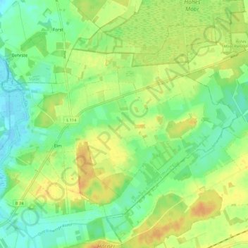
Name: Elm topographic map, elevation, terrain.
Average elevation: 15 m
Minimum elevation: -1 m
Maximum elevation: 32 m
Other topographic maps
Click on a map to view its topography, its elevation and its terrain.
Nieder Ochtenhausen
Deutschland > Niedersachsen > Landkreis Rotenburg (Wümme) > Bremervörde
Nieder Ochtenhausen, Bremervörde, Landkreis Rotenburg (Wümme), Niedersachsen, Deutschland
Average elevation: 5 m