
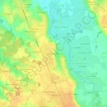
Grand Montatin topographic map
Interactive map
Click on the map to display elevation.
About this map
Name: Grand Montatin topographic map, elevation, terrain.
Average elevation: 210 m
Minimum elevation: 192 m
Maximum elevation: 227 m
Other topographic maps
Click on a map to view its topography, its elevation and its terrain.
Cras-sur-Reyssouze
France > Auvergne-Rhône-Alpes > Ain > Bresse Vallons
Cras-sur-Reyssouze, Bresse Vallons, Bourg-en-Bresse, Ain, Auvergne-Rhône-Alpes, France métropolitaine, 01340, France
Average elevation: 210 m
Étrez
France > Auvergne-Rhône-Alpes > Ain > Bresse Vallons
Étrez, Bresse Vallons, Bourg-en-Bresse, Ain, Auvergne-Rhône-Alpes, France métropolitaine, 01340, France
Average elevation: 215 m
Le Moulin
France > Auvergne-Rhône-Alpes > Ain > Bresse Vallons > Le Moulin
Le Moulin, Cras-sur-Reyssouze, Bresse Vallons, Bourg-en-Bresse, Ain, Auvergne-Rhône-Alpes, France métropolitaine, 01340, France
Average elevation: 211 m
Étrez
France > Auvergne-Rhône-Alpes > Ain > Bresse Vallons
Étrez, Bresse Vallons, Bourg-en-Bresse, Ain, Auvergne-Rhône-Alpes, France métropolitaine, 01340, France
Average elevation: 217 m