
Thank you for supporting this site ❤️
Make a donation
Make a donation
Gear up for your next adventure:
As an Amazon Associate, this site earns from qualifying purchases at no extra cost to you.
Southlake topographic map
Click on the map to display elevation.
Thank you for supporting this site ❤️
Make a donation
Make a donation
Gear up for your next adventure:
As an Amazon Associate, this site earns from qualifying purchases at no extra cost to you.
About this map
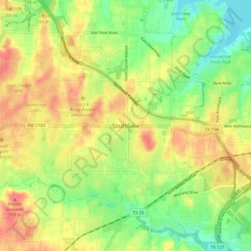
Name: Southlake topographic map, elevation, terrain.
Location: Southlake, Tarrant County, Texas, 76092, United States (32.90124 -97.17418 32.98124 -97.09418)
Average elevation: 190 m
Minimum elevation: 160 m
Maximum elevation: 218 m
Thank you for supporting this site ❤️
Make a donation
Make a donation
Gear up for your next adventure:
🎒40L Day Hiking Backpacks - Comfortable packs with hydration support for long days exploring topographic peaks
🧭Global Orienteering Compass - High-precision liquid-filled compasses for accurate map reading and navigation
As an Amazon Associate, this site earns from qualifying purchases at no extra cost to you.