Geolocate

Kulapi topographic map

Click on the map to display elevation.

About this map

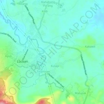
Name: Kulapi topographic map, elevation, terrain.

Location: Kulapi, Quezon, Calabarzon, 4328, Philippines (14.09264 121.54778 14.13264 121.58778)

Average elevation: 439 m

Minimum elevation: 391 m

Maximum elevation: 644 m

Gear up for your next adventure:

🛰️Handheld GPS Units - Rugged GPS devices for tracking coordinates and elevation in the Australian bush
🔪Camping Knives - Multi-purpose outdoor knives
🧤Thermal Hiking Gloves - Keep your hands warm and functional during high-altitude winter treks
🏃Compression Recovery Socks - Reduce leg fatigue after heavy days of elevation gain
👟Lightweight Trail Runners - Agile footwear for fast movement over rugged Australian terrain

As an Amazon Associate, this site earns from qualifying purchases at no extra cost to you.