
Rufford topographic map
Click on the map to display elevation.
About this map
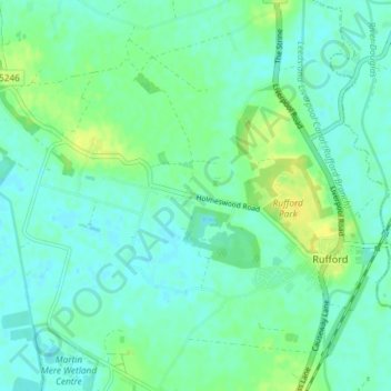
Name: Rufford topographic map, elevation, terrain.
Location: Rufford, West Lancashire, Lancashire, England, United Kingdom (53.62181 -2.87923 53.65858 -2.80583)
Average elevation: 8 m
Minimum elevation: 1 m
Maximum elevation: 21 m
Other topographic maps
Click on a map to view its topography, its elevation and its terrain.
Scarth Hill
United Kingdom > England > Lancashire > West Lancashire > Ormskirk
Average elevation: 58 m
Bury Hey Wood
United Kingdom > England > Lancashire > West Lancashire > Appley Bridge > Robin Hood
Average elevation: 106 m
Tontine
United Kingdom > England > Lancashire > West Lancashire > Upholland > Tontine
Average elevation: 101 m
Bury Hey Wood
United Kingdom > England > Lancashire > West Lancashire > Appley Bridge > Robin Hood
Average elevation: 106 m