Geolocate

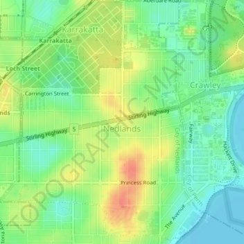
Nedlands topographic map

Click on the map to display elevation.

Nedlands

Due to its elevation, Nedlands is slightly cooler and wetter than the Perth central business district.

Wikipedia (CC-BY-SA 3.0)

About this map

Name: Nedlands topographic map, elevation, terrain.

Location: Nedlands, City of Nedlands, Western Australia, 6009, Australia (-31.99384 115.78818 -31.96441 115.81827)

Average elevation: 20 m

Minimum elevation: 0 m

Maximum elevation: 46 m

City of Nedlands trails, hiking, mountain biking, running and outdoor activities

Other topographic maps

Click on a map to view its topography, its elevation and its terrain.

Gear up for your next adventure:

🧥Thermal Emergency Blankets - Compact Mylar blankets to prevent hypothermia if stranded overnight
🦟Insect Repellent - Protection against insects
📡Weather Radios - Emergency weather radios
🧥Insulated Down Jackets - High warmth-to-weight ratio for cold nights in the high country
⌚Altimeter Watches - Watches with altitude tracking

As an Amazon Associate, this site earns from qualifying purchases at no extra cost to you.