
Barnstable topographic map
Click on the map to display elevation.
About this map
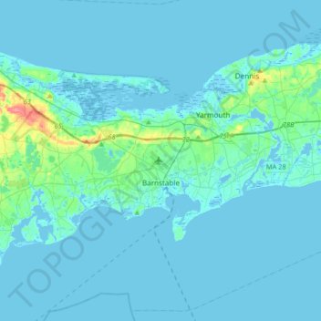
Name: Barnstable topographic map, elevation, terrain.
Location: Barnstable, Barnstable County, Massachusetts, United States (41.54852 -70.46760 41.79328 -70.25963)
Average elevation: 7 m
Minimum elevation: -6 m
Maximum elevation: 79 m
Other topographic maps
Click on a map to view its topography, its elevation and its terrain.
Shank Painter Pond
United States > Massachusetts > Barnstable County > Provincetown
Average elevation: 4 m
Mayflower Heights
United States > Massachusetts > Barnstable County > Provincetown
Average elevation: 2 m
East Brewster
United States > Massachusetts > Barnstable County > Brewster > East Brewster
Average elevation: 16 m
Harwich Port
United States > Massachusetts > Barnstable County > Harwich > Harwich Port
Average elevation: 3 m