
Ancín topographic map
Interactive map
Click on the map to display elevation.
About this map
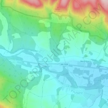
Name: Ancín topographic map, elevation, terrain.
Location: Ancín, Montejurra, Navarra, España (42.64305 -2.21192 42.68056 -2.16048)
Average elevation: 533 m
Minimum elevation: 464 m
Maximum elevation: 740 m
Other topographic maps
Click on a map to view its topography, its elevation and its terrain.
Río Urederra
España > Navarra > Montejurra > Améscoa Baja > Zudaire
Río Urederra, Zudaire, Améscoa Baja, Montejurra, Navarra, España
Average elevation: 759 m