
Mont-Dore topographic map
Interactive map
Click on the map to display elevation.
About this map
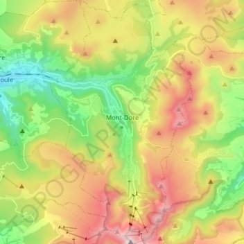
Name: Mont-Dore topographic map, elevation, terrain.
Average elevation: 1,300 m
Minimum elevation: 860 m
Maximum elevation: 1,872 m
Der Ort liegt nördlich vom Puy de Sancy in einem Tal an der Dordogne im Bergmassiv Monts Dore in über 1.000 m Höhe.
Other topographic maps
Click on a map to view its topography, its elevation and its terrain.
Puy de Sancy
Frankreich > Auvergne-Rhone-Alpen > Mont-Dore
Puy de Sancy, Mont-Dore, Issoire, Puy-de-Dôme, Auvergne-Rhone-Alpen, Metropolitanes Frankreich, 63240, Frankreich
Average elevation: 1,601 m