
Sengern topographic map
Interactive map
Click on the map to display elevation.
About this map
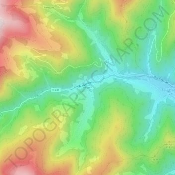
Name: Sengern topographic map, elevation, terrain.
Average elevation: 697 m
Minimum elevation: 408 m
Maximum elevation: 1,128 m
Other topographic maps
Click on a map to view its topography, its elevation and its terrain.
Felsenbach
France > Grand Est > Haut-Rhin > Lautenbachzell > Sengern
Felsenbach, Sengern, Lautenbachzell, Thann-Guebwiller, Haut-Rhin, Grand Est, France métropolitaine, 68610, France
Average elevation: 712 m
Lieserwasen
France > Grand Est > Haut-Rhin > Lautenbachzell
Lieserwasen, Lautenbachzell, Thann-Guebwiller, Haut-Rhin, Grand Est, France métropolitaine, 68610, France
Average elevation: 895 m
Lac de la Lauch
France > Grand Est > Haut-Rhin > Lautenbachzell
Lac de la Lauch, Lautenbachzell, Thann-Guebwiller, Haut-Rhin, Grand Est, France métropolitaine, 68610, France
Average elevation: 1,085 m