
Thank you for supporting this site ❤️
Make a donation
Make a donation
Gear up for your next adventure:
As an Amazon Associate, this site earns from qualifying purchases at no extra cost to you.
Pushkar topographic map
Click on the map to display elevation.
Thank you for supporting this site ❤️
Make a donation
Make a donation
Gear up for your next adventure:
As an Amazon Associate, this site earns from qualifying purchases at no extra cost to you.
About this map
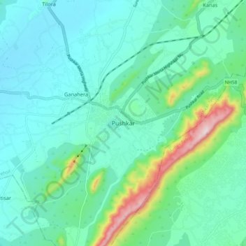
Name: Pushkar topographic map, elevation, terrain.
Location: Pushkar, Pushkar Tehsil, Ajmer, Rajasthan, 305022, India (26.44765 74.51785 26.52765 74.59785)
Average elevation: 516 m
Minimum elevation: 428 m
Maximum elevation: 882 m
Thank you for supporting this site ❤️
Make a donation
Make a donation
Gear up for your next adventure:
As an Amazon Associate, this site earns from qualifying purchases at no extra cost to you.