
Make a donation
Gear up for your next adventure:
As an Amazon Associate, this site earns from qualifying purchases at no extra cost to you.
Vandalur topographic map
Click on the map to display elevation.
Make a donation
Gear up for your next adventure:
As an Amazon Associate, this site earns from qualifying purchases at no extra cost to you.
Vandalur
Arignar Anna Zoological Park is located in Vandalur. It was established as Chennai zoo in 1855 and was the first public zoo in India. The construction of the new zoo at Vandalur started in 1979 and the zoo moved to the locality in 1985. As of 2023, the zoo is spread over an area of 602 hectares and houses 2,149 animals in 89 enclosures. Vandalur hill is part of the zoological park and is situated at an altitude of 126 m (413 ft).
Make a donation
Gear up for your next adventure:
As an Amazon Associate, this site earns from qualifying purchases at no extra cost to you.
About this map
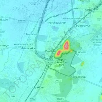
Name: Vandalur topographic map, elevation, terrain.
Location: Vandalur, Chengalpattu, Tamil Nadu, 603210, India (12.85215 80.04296 12.93215 80.12296)
Average elevation: 27 m
Minimum elevation: 13 m
Maximum elevation: 160 m
Make a donation
Gear up for your next adventure:
As an Amazon Associate, this site earns from qualifying purchases at no extra cost to you.
Other topographic maps
Click on a map to view its topography, its elevation and its terrain.
Make a donation
Gear up for your next adventure:
As an Amazon Associate, this site earns from qualifying purchases at no extra cost to you.
Make a donation
Gear up for your next adventure:
As an Amazon Associate, this site earns from qualifying purchases at no extra cost to you.