Geolocate

Manangle topographic map

Click on the map to display elevation.

About this map

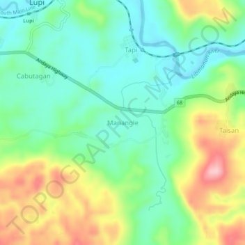
Name: Manangle topographic map, elevation, terrain.

Location: Manangle, Camarines Sur, Bicol Region, Philippines (13.75056 122.90341 13.79056 122.94341)

Average elevation: 74 m

Minimum elevation: 7 m

Maximum elevation: 196 m

Gear up for your next adventure:

🩹Blister Prevention Tape - Apply to friction points before they become painful sores
🔥Windproof Plasma Lighters - USB rechargeable lighters that work in high-altitude winds
🥾Hiking Gaiters - Leg protection for trails
🎽Base Layers - Thermal base layers
🦯Adjustable Trekking Poles - Reduce impact on knees when descending steep topographic ridges

As an Amazon Associate, this site earns from qualifying purchases at no extra cost to you.