
Make a donation
Gear up for your next adventure:
As an Amazon Associate, this site earns from qualifying purchases at no extra cost to you.
Myerstown topographic map
Click on the map to display elevation.
Make a donation
Gear up for your next adventure:
As an Amazon Associate, this site earns from qualifying purchases at no extra cost to you.
About this map
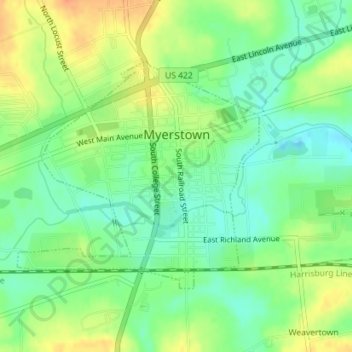
Name: Myerstown topographic map, elevation, terrain.
Location: Myerstown, Lebanon County, Pennsylvania, United States (40.36346 -76.31952 40.38092 -76.29516)
Average elevation: 147 m
Minimum elevation: 128 m
Maximum elevation: 170 m
Make a donation
Gear up for your next adventure:
As an Amazon Associate, this site earns from qualifying purchases at no extra cost to you.
Other topographic maps
Click on a map to view its topography, its elevation and its terrain.
Sunset
United States > Pennsylvania > Lebanon County > North Lebanon Township
Average elevation: 180 m
Fort Indiantown Gap
United States > Pennsylvania > Lebanon County > Union Township
Average elevation: 217 m
Lights Dam
United States > Pennsylvania > Lebanon County > North Lebanon Township > Ebenezer
Average elevation: 168 m
Woodfort
United States > Pennsylvania > Lebanon County > North Cornwall Township
Average elevation: 144 m
Make a donation
Gear up for your next adventure:
As an Amazon Associate, this site earns from qualifying purchases at no extra cost to you.