
Make a donation
Gear up for your next adventure:
As an Amazon Associate, this site earns from qualifying purchases at no extra cost to you.
Talagante topographic map
Click on the map to display elevation.
Make a donation
Gear up for your next adventure:
As an Amazon Associate, this site earns from qualifying purchases at no extra cost to you.
Talagante
Talagante can be found in the Chilean Central Valley at an elevation of 313 m (1,027 ft), 35 kilometres (22 mi) to the southwest of the national capital of Santiago. The commune spans an area of 125.5 km2 (48 sq mi).
Make a donation
Gear up for your next adventure:
As an Amazon Associate, this site earns from qualifying purchases at no extra cost to you.
About this map
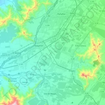
Name: Talagante topographic map, elevation, terrain.
Average elevation: 390 m
Minimum elevation: 200 m
Maximum elevation: 1,329 m
Make a donation
Gear up for your next adventure:
As an Amazon Associate, this site earns from qualifying purchases at no extra cost to you.
Other topographic maps
Click on a map to view its topography, its elevation and its terrain.
Santa Mónica Norte
Chile > Santiago Metropolitan Region > Provincia de Talagante
Average elevation: 487 m
El Peumo
Chile > Santiago Metropolitan Region > Provincia de Talagante > Talagante
Average elevation: 324 m
Don Benedicto
Chile > Santiago Metropolitan Region > Provincia de Talagante > Peñaflor
Average elevation: 416 m