Geolocate

Barlo topographic map

Click on the map to display elevation.

About this map

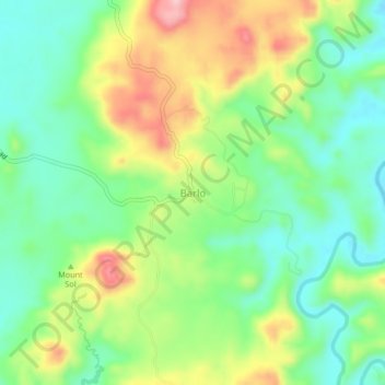
Name: Barlo topographic map, elevation, terrain.

Location: Barlo, Pangasinan, Ilocos Region, Philippines (15.97093 119.92657 16.01093 119.96657)

Average elevation: 95 m

Minimum elevation: 24 m

Maximum elevation: 210 m

Gear up for your next adventure:

🧭Military Style Lensatic Compass - Durable sighting compasses for advanced land navigation and surveying
📦Crushproof Equipment Cases - Safe transport for sensitive surveying and mapping instruments
💧Personal Water Filters - Drink safely from streams and lakes identified on your map
🧊Insulated Stainless Steel Flasks - Keep water cold for 24 hours in the heat or coffee hot in the cold
🎒40L Day Hiking Backpacks - Comfortable packs with hydration support for long days exploring topographic peaks

As an Amazon Associate, this site earns from qualifying purchases at no extra cost to you.