
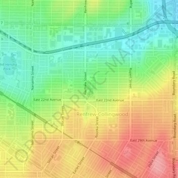
Still Creek topographic map
Interactive map
Click on the map to display elevation.
About this map
Name: Still Creek topographic map, elevation, terrain.
Average elevation: 65 m
Minimum elevation: 18 m
Maximum elevation: 119 m
Other topographic maps
Click on a map to view its topography, its elevation and its terrain.
Stanley Park
Canada > British Columbia > Metro Vancouver Regional District > Vancouver
Stanley Park, West End, Vancouver, Metro Vancouver Regional District, British Columbia, V6G, Canada
Average elevation: 14 m
Kitsilano
Canada > British Columbia > Metro Vancouver Regional District > Vancouver
Kitsilano, Vancouver, Metro Vancouver Regional District, British Columbia, Canada
Average elevation: 24 m
Kerrisdale
Canada > British Columbia > Metro Vancouver Regional District > Vancouver
Kerrisdale, Vancouver, Metro Vancouver Regional District, British Columbia, Canada
Average elevation: 39 m
Queen Elizabeth Park
Canada > British Columbia > Metro Vancouver Regional District > Vancouver
Queen Elizabeth Park, Riley Park, Vancouver, Metro Vancouver Regional District, British Columbia, V5Y, Canada
Average elevation: 81 m
Killarney
Canada > British Columbia > Metro Vancouver Regional District > Vancouver
Killarney, Vancouver, Metro Vancouver Regional District, British Columbia, Canada
Average elevation: 73 m
False Creek
Canada > British Columbia > Metro Vancouver Regional District > Vancouver
False Creek, Fairview, Vancouver, Metro Vancouver Regional District, British Columbia, V6A, Canada
Average elevation: 18 m
Andy Livingstone Park
Canada > British Columbia > Metro Vancouver Regional District > Vancouver
Andy Livingstone Park, Chinatown, Downtown, Vancouver, Metro Vancouver Regional District, British Columbia, V6A, Canada
Average elevation: 12 m
West End
Canada > British Columbia > Metro Vancouver Regional District > Vancouver
West End, Vancouver, Metro Vancouver Regional District, British Columbia, Canada
Average elevation: 15 m
English Bay Beach
Canada > British Columbia > Metro Vancouver Regional District > Vancouver
English Bay Beach, Davie Village, West End, Vancouver, District of North Vancouver, Metro Vancouver Regional District, British Columbia, V6G, Canada
Average elevation: 12 m
Fairview
Canada > British Columbia > Metro Vancouver Regional District > Vancouver
Fairview, Vancouver, Metro Vancouver Regional District, British Columbia, Canada
Average elevation: 31 m
Fraser River Park
Canada > British Columbia > Metro Vancouver Regional District > Vancouver
Fraser River Park, Marpole, Kerrisdale, Vancouver, Metro Vancouver Regional District, British Columbia, V6P, Canada
Average elevation: 19 m
Strathcona Park
Canada > British Columbia > Metro Vancouver Regional District > Vancouver
Strathcona Park, Cottonwood Community Garden, Strathcona, Vancouver, District of North Vancouver, Metro Vancouver Regional District, British Columbia, V6A, Canada
Average elevation: 17 m
Arbutus-Ridge
Canada > British Columbia > Metro Vancouver Regional District > Vancouver
Arbutus-Ridge, Vancouver, Metro Vancouver Regional District, British Columbia, Canada
Average elevation: 60 m
Downtown
Canada > British Columbia > Metro Vancouver Regional District > Vancouver
Downtown, Vancouver, Metro Vancouver Regional District, British Columbia, Canada
Average elevation: 15 m
Kitsilano 6
Canada > British Columbia > Metro Vancouver Regional District > Vancouver
Kitsilano 6, Fairview, Vancouver, Metro Vancouver Regional District, British Columbia, V6J, Canada
Average elevation: 22 m
McBride Park
Canada > British Columbia > Metro Vancouver Regional District > Vancouver
McBride Park, Kitsilano, Vancouver, Metro Vancouver Regional District, British Columbia, V6R, Canada
Average elevation: 22 m
Hastings-Sunrise
Canada > British Columbia > Metro Vancouver Regional District > Vancouver
Hastings-Sunrise, Vancouver, Metro Vancouver Regional District, British Columbia, Canada
Average elevation: 42 m
Strathcona
Canada > British Columbia > Metro Vancouver Regional District > Vancouver
Strathcona, Vancouver, Metro Vancouver Regional District, British Columbia, V6A, Canada
Average elevation: 10 m
Shaughnessy
Canada > British Columbia > Metro Vancouver Regional District > Vancouver
Shaughnessy, Vancouver, Metro Vancouver Regional District, British Columbia, Canada
Average elevation: 74 m
Point Grey Park Site at Trutch Street
Canada > British Columbia > Metro Vancouver Regional District > Vancouver
Point Grey Park Site at Trutch Street, Kitsilano, Vancouver, District of North Vancouver, Metro Vancouver Regional District, British Columbia, V6K, Canada
Average elevation: 15 m
Riley Park
Canada > British Columbia > Metro Vancouver Regional District > Vancouver
Riley Park, Vancouver, Metro Vancouver Regional District, British Columbia, Canada
Average elevation: 75 m
Slocan Park
Canada > British Columbia > Metro Vancouver Regional District > Vancouver
Slocan Park, Renfrew-Collingwood, Vancouver, Metro Vancouver Regional District, British Columbia, V5R, Canada
Average elevation: 81 m
Charleson Park
Canada > British Columbia > Metro Vancouver Regional District > Vancouver
Charleson Park, Fairview, Vancouver, District of North Vancouver, Metro Vancouver Regional District, British Columbia, V6H, Canada
Average elevation: 28 m
Brewers Park
Canada > British Columbia > Metro Vancouver Regional District > Vancouver
Brewers Park, Kensington-Cedar Cottage, Vancouver, District of North Vancouver, Metro Vancouver Regional District, British Columbia, Canada
Average elevation: 64 m
Gaston Park
Canada > British Columbia > Metro Vancouver Regional District > Vancouver
Gaston Park, Renfrew-Collingwood, Vancouver, Metro Vancouver Regional District, British Columbia, Canada
Average elevation: 104 m
John Hendry Park
Canada > British Columbia > Metro Vancouver Regional District > Vancouver
John Hendry Park, Vancouver, Metro Vancouver Regional District, British Columbia, V5N, Canada
Average elevation: 52 m