
Yamanouchi topographic map
Interactive map
Click on the map to display elevation.
About this map
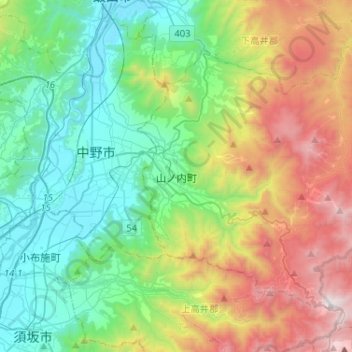
Name: Yamanouchi topographic map, elevation, terrain.
Location: Yamanouchi, Shimotakai County, Nagano Prefecture, Japan (36.66571 138.38338 36.82465 138.64215)
Average elevation: 942 m
Minimum elevation: 305 m
Maximum elevation: 2,303 m
Other topographic maps
Click on a map to view its topography, its elevation and its terrain.
Nozawaonsen
Nozawaonsen, Shimotakai County, Nagano Prefecture, 389-2502, Japan
Average elevation: 710 m