Geolocate

Longtan topographic map

Click on the map to display elevation.

About this map

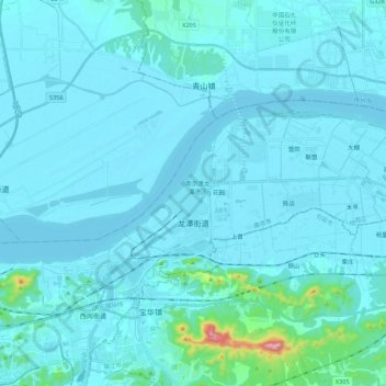
Name: Longtan topographic map, elevation, terrain.

Location: Longtan, Qixia District, Nanjing City, Jiangsu, China (32.15798 119.02149 32.24706 119.23951)

Average elevation: 25 m

Minimum elevation: -1 m

Maximum elevation: 422 m

Gear up for your next adventure:

🎒Dry Bags - Waterproof bags for outdoor gear
🌿Flora and Fauna Field Guides - Identify the plants and animals you encounter on your route
🦘Outback Survival Gear - Essential gear for Australian outback
🧥Insulated Down Jackets - High warmth-to-weight ratio for cold nights in the high country
🔋Rechargeable Batteries - Eco-friendly power for high-drain GPS units and flashlights

As an Amazon Associate, this site earns from qualifying purchases at no extra cost to you.