
Province of Satipo topographic map
Interactive map
Click on the map to display elevation.
About this map
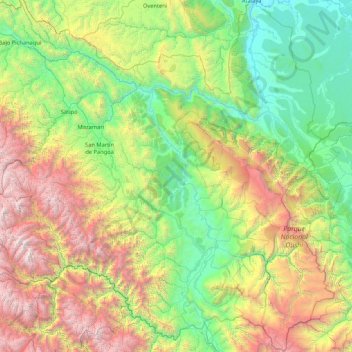
Name: Province of Satipo topographic map, elevation, terrain.
Location: Province of Satipo, Junín, 12260, Peru (-12.38699 -75.05100 -10.73401 -73.35513)
Average elevation: 1,559 m
Minimum elevation: 204 m
Maximum elevation: 5,186 m
Elevations and climates in Satipo province range from the Amazon Basin tropical rainforest climate along the Tambo River near Atalaya at an elevation of 207 m (679 ft) to Nevado Bateadora with an elevation of 4,866 m (15,965 ft) near the hamlet of Toldopampa in the Andes.
Other topographic maps
Click on a map to view its topography, its elevation and its terrain.
Concepción
Peru > Junín > Concepción
Concepción, Province of Concepción, Junín, 12125, Peru
Average elevation: 3,344 m