Geolocate

Bombo topographic map

Interactive map

Click on the map to display elevation.

About this map

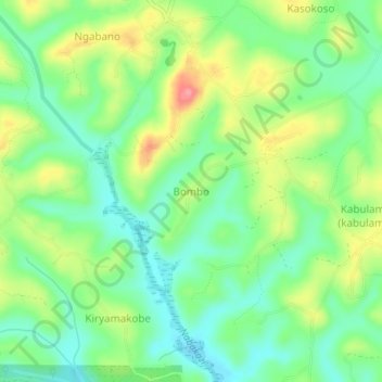
Name: Bombo topographic map, elevation, terrain.

Location: Bombo, Mubende, Central Region, Uganda (0.64803 31.46103 0.68803 31.50103)

Average elevation: 1,290 m

Minimum elevation: 1,254 m

Maximum elevation: 1,350 m

Other topographic maps

Click on a map to view its topography, its elevation and its terrain.

Nabingora

Uganda > Mubende

Nabingora, Mubende, Central Region, Uganda

Average elevation: 1,347 m

Kiyuya

Uganda > Mubende

Kiyuya, Mubende, Central Region, Uganda

Average elevation: 1,320 m

Kibanyi

Uganda > Mubende

Kibanyi, Mubende, Central Region, Uganda

Average elevation: 1,286 m

Mubende

Uganda > Mubende

Mubende, Central Region, Uganda

Average elevation: 1,303 m

Madudu

Uganda > Mubende

Madudu, Mubende, Central Region, Uganda

Average elevation: 1,237 m

Nabakazi

Uganda > Mubende

Nabakazi, Mubende, Central Region, Uganda

Average elevation: 1,186 m

Kyenda

Uganda > Mubende

Kyenda, Mubende, Central Region, Uganda

Average elevation: 1,272 m